i.The Volcanic Plateau and the Soft Stone
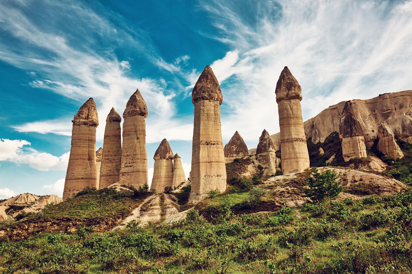
Cappadocia is, before it is anything else, a piece of geology. About three million years ago — at the boundary of the Pliocene and the Pleistocene — three great volcanoes of the central Anatolian plateau, Mount Erciyes (Argaios) above Kayseri, Mount Hasan west of Aksaray, and the smaller Melendiz Dağı south of them, erupted in a long sequence that buried the country for two hundred kilometres in every direction under successive layers of soft volcanic tuff. The eruptions ended; the wind, the rain, and the small rivers of the plateau — the Kızılırmak, the Damsa Çayı, the Soğanlı — went to work on the tuff. They cut down through it unevenly, leaving harder caps of basalt on top of softer columns, and over those long Pliocene-and-Pleistocene millennia they produced the landscape the world now knows: pinnacles capped with stone hats, fluted ridges in honey and rose, ravines that fold away into the plain, and the conical formations the Turks call peri bacaları — fairy chimneys.
The tuff has one other property: it cuts cleanly with a hand tool, and once cut it hardens slowly to the touch of air. That single fact is the reason Cappadocia became, for nearly four thousand years, the great trans-Anatolian country of rock-cut architecture — Hittite-period storage rooms, Iron Age tomb chambers, Byzantine rock churches with painted apses, Seljuk and Ottoman house-cellars and dovecotes, the great underground cities of Derinkuyu and Kaymaklı. The plateau is, in this sense, a single building material. What rose above it disappeared in many places; what was carved into it largely survives.
ii.Kanesh, Kaneš, Kültepe — the Assyrian Trading Colony
The earliest layer of written history on this plateau is older than that of any other site in Türkiye. At the mound called Kültepe, twenty kilometres northeast of modern Kayseri, archaeologists have uncovered the Bronze Age city the Hittite-period sources call Kaneš and the modern literature usually writes Kanesh. Below the citadel mound, in the lower town the Assyrians knew as the kārum — the merchant quarter — lie the remains of an Old Assyrian trading colony active between roughly 1950 and 1750 BCE. The kārum traders kept their records on small clay tablets in cuneiform; tens of thousands of those tablets have been recovered from Kültepe, and they are, in Britannica's plain summary, "among the oldest written documents discovered in Türkiye." They record textile and tin caravans from Aššur, marriage contracts, lawsuits, debt instruments — a corner of the early-Mesopotamian world transplanted into the central Anatolian plateau.
The tablets are also the first records to use the name Kanesh for a political centre, and the city itself was, at its height, the seat of a small Anatolian kingdom from which the Hittite royal house claimed descent. After about 1750 BCE Kanesh declines; by the time the Hittite Old Kingdom is unifying central Anatolia from Hattusha to the north — see our essay on Hattusha — Kültepe has become a provincial centre rather than the metropolis it was.
iii.From Hittite Land to Persian Satrapy
Through the Hittite imperial centuries (c. 1650–1200 BCE) the country of the volcanoes is the southern part of the Hittite homeland, controlled from Hattusha. After the Bronze Age collapse around 1200 BCE the plateau passes through obscure Iron Age centuries about which the textual record has little to say. It re-emerges, in the 6th century BCE, under the name Katpatuka in Old Persian inscriptions and Kappadokía in the Greek of Herodotus, as a Persian satrapy of the Achaemenid empire. The satrapy was ruled by a Persian-descended noble house; the religious life that the Greek writers describe is essentially Zoroastrian, with temple-cults of fire and of the river. Cappadocia in this period is the inland counterpart of the great Lydian satrapy of Sardis to the west.
iv.The Hellenistic Kingdom and the Roman Province
Alexander's conquest of the Persian empire in 330 BCE reached Cappadocia, but the country was not easily Hellenised. Alexander's general Perdiccas campaigned here in 322 BCE; in the wars of the Diadochi that followed, a local dynasty under Ariarathes reasserted itself, and from the mid-3rd century BCE Cappadocia existed as an independent Hellenistic kingdom — Greek in court culture, Iranian in nobility, mixed in language — for nearly three centuries. After the Roman victory at Magnesia over the Seleucids in 190 BCE Cappadocia became a Roman client state; in 17 CE, under the emperor Tiberius, it was annexed outright and made a Roman province, with its administrative centre at Caesarea — Greek Kaisáreia, modern Kayseri — at the foot of Mount Erciyes.
What Rome valued in the province was its strategic position: the Taurus passes, especially the Cilician Gates south of Caesarea, were the gateway between the Anatolian plateau and the Syrian and Mesopotamian frontier. Cappadocia became the staging ground for the eastern campaigns. The cities along the trans-Anatolian road — Caesarea, Tyana, Comana, Sebasteia — flourished; the plateau itself, agricultural and pastoral, fed the legions.
v.The Cappadocian Fathers — 4th-century Christian Anatolia
In the second half of the 4th century, in the generation after Constantine's establishment of Christianity as the favoured religion of the Roman empire, Cappadocia became, almost without warning, one of the most theologically important provinces of the eastern church. Three native bishops of the region — Basil of Caesarea (c. 330–379), bishop of the provincial capital; Gregory of Nyssa (c. 335–c. 395), Basil's younger brother and bishop of the small Cappadocian town of Nyssa; and Gregory of Nazianzus (c. 329–390), Basil's friend and briefly bishop of Constantinople, born at the village of Nazianzus near modern Aksaray — together produced the body of writing on the Trinity that the Greek-speaking church would carry forward into the Byzantine centuries. They are known collectively as the Cappadocian Fathers, and they fought, especially, the long doctrinal battle against Arianism, defending the formula on which the eastern church settled at the Council of Constantinople in 381.
Their importance for the landscape is twofold. The monastic rule that Basil wrote for the Cappadocian countryside — the Asketika — became the foundational rule of all Greek Christian monasticism. And the network of small monastic communities that grew up across the volcanic plateau in the centuries after them, eventually carving the rock churches whose painted apses are now the heart of the UNESCO inscription, traced its institutional descent through Basil's rule.
vi.The Rock-Cut Churches of Göreme and the Byzantine Province
Through the Byzantine centuries Cappadocia, in Britannica's phrase, was "a bulwark of the Byzantine Empire" — the southern wall of imperial Anatolia, fortified by its natural geography against the great waves of incursion from the east. After the Sasanian raids of 611 CE and the Arab attacks that followed through the 7th to 10th centuries, the population of the plateau increasingly took to the rock. Existing tuff-cut spaces were enlarged into refuges; entire villages went underground for weeks at a time; and the monastic communities that traced themselves back to Basil began to expand their cave-churches into the elaborate fresco-painted sanctuaries we know today.
The greatest surge came in the 10th and 11th centuries, after the iconoclastic controversies had been settled and the empire enjoyed a rare interval of stability under the Macedonian emperors. At Göreme — a single valley a few kilometres east of modern Nevşehir — a cluster of rock-cut churches and refectories grew up around a small monastic settlement. The most famous of them, all now part of the Göreme Open-Air Museum, are the Tokalı Kilise (Buckle Church), the Karanlık Kilise (Dark Church), the Elmalı Kilise (Apple Church), the Çarıklı Kilise (Sandal Church), the Yılanlı Kilise (Snake Church), the chapels of Aziz Barbara and Aziz Basil, and the small Meryem Ana (Saint Mary) chapel. Their painted apses, in red ochre, lapis blue, and gold-leaf yellow, are the principal evidence for what the great mosaic-and-fresco programmes of Byzantine Constantinople looked like in their post-Iconoclastic prime. The standard scholarly account is Lyn Rodley's Cave Monasteries of Byzantine Cappadocia (Cambridge, 1985).
Beyond Göreme proper the rock churches and monasteries extend across the whole plateau: Soğanlı south of Ürgüp; Ihlara Vadisi in Aksaray province, with its long fresco-lined gorge along the Melendiz Çayı; Açıksaray near Gülşehir; the basilica complex of Çavuşin (Saint John the Baptist) north of Göreme; and the rock town of Ortahisar, which is itself carved out of a single great mass of tuff.
vii.The Underground Cities — Derinkuyu, Kaymaklı, and the Refuges
If the rock-cut churches are Cappadocia's gift to the history of Byzantine art, the underground cities are its gift to the history of refuge. The largest are at Derinkuyu — eight known levels, with a depth of about 85 metres and an estimated capacity in the low tens of thousands — and Kaymaklı, slightly smaller but better preserved at the upper levels. Mazıköy, Özkonak, and several others are open to the public; perhaps a hundred more are partially excavated or known only from local memory. All share the same architectural vocabulary: a narrow surface entrance disguised among houses; long sloping corridors with great millstone-shaped doors that could be rolled across them; on each successive level, kitchens with chimneys vented kilometres away through the tuff, churches, schoolrooms, storage chambers for grain and oil, stables, wineries, and at the deepest level a ventilation shaft and a well.
The dating of the underground cities is uncertain — the tuff cannot be carbon-dated, and the spaces were re-used continuously — but the consensus is that they grew in their present form between the 7th and 10th centuries, in response first to the Arab incursions and then to the slow tightening of the eastern frontier under the early Abbasid caliphate. They were used again, by Greek and Armenian Christian communities, during the Seljuk and later periods, and the last recorded use of Derinkuyu as a refuge dates to the early 20th century. To descend into them now is to walk, in cold air at twelve degrees Celsius, through several centuries of a particular way of living with siege.
viii.Seljuks, Hacı Bektaş Veli, and the Anatolian Synthesis
The Seljuk Turks reached Cappadocia after the Byzantine collapse at Manzikert in 1071, and within a generation the country was incorporated into the Seljuk Sultanate of Rûm — see our essay on the Seljuks based at Konya. The Seljuk centuries left their own architectural layer on the plateau: caravanserais along the trans-Anatolian road, of which the great Sarı Han just east of Avanos is the standing example; mosques and medreses in Kayseri, Niğde, and Aksaray; and a long, slow demographic and religious shift, as Turkmen populations settled the plateau alongside the Greek-Orthodox and Armenian communities that had carved the rock churches.
It is in this post-Seljuk Anatolia that the figure of Hacı Bektâş-ı Velî appears — a wandering Khorasani dervish who came to the small Cappadocian village of Sulucakarahöyük (the place that bears his name today, Hacıbektaş, in northern Nevşehir) sometime after the death of his teacher Baba İlyâs-ı Horasânî in the early 13th century. A waqf document of 691 AH / 1292 CE refers to him as already deceased; the conventional date for his death is 1271. Around his tomb a lodge grew up; out of that lodge, through the 14th century, the Bektaşi tradition took shape — a Sufi order, syncretic in its theology, organised in confraternities, and from the 15th century onward closely tied to the Janissary corps of the Ottoman empire. The Pir Evi at Hacıbektaş remained the spiritual centre of the order until the dissolution of the Sufi lodges by the Republic in 1925; the complex now operates as the Hacıbektaş Museum. The standard scholarly treatment is Irène Mélikoff's Hadji Bektach: Un mythe et ses avatars (Leiden: Brill, 1998).
ix.UNESCO and the Modern Region
In 1985, UNESCO inscribed Göreme National Park and the Rock Sites of Cappadocia on the World Heritage List as a mixed (cultural and natural) property, under four of the ten World Heritage criteria — (i) for the rock sanctuaries as a unique artistic achievement; (iii) for the fossilised image they preserve of a Byzantine province between the 4th century and the Seljuk arrival; (v) as an outstanding example of a traditional human settlement made vulnerable by erosion and tourism; and (vii) for the spectacular natural landscape of the fairy chimneys themselves. The inscription covers the area between Nevşehir, Ürgüp, and Avanos, with named sites at Karain, Karlık, Yeşilöz, and Soğanlı, and the underground cities of Kaymaklı and Derinkuyu.
The same period — the 1980s and after — saw the rise of the hot-air-balloon industry that is now the defining image of the region for international visitors. The first commercial flights over the valleys of Cappadocia date to the 1990s; today, in a normal season, a hundred or more balloons rise at dawn from the Göreme and Çavuşin valleys, and the silhouette of the balloons against the pink tuff at sunrise has become, for better or worse, one of the small handful of universally recognisable images of Türkiye. The province is administered for World Heritage purposes by the Kapadokya Alan Başkanlığı, an autonomous agency under the Ministry of Culture and Tourism since 2019, whose remit is to balance the conservation of the rock heritage against the pressures of mass tourism.
x.What to See — Towns, Valleys, Underground Cities
The walking shape of touristic Cappadocia is, like its geology, more horizontal than vertical. The classic three-day itinerary moves between three small towns and the valleys between them. Göreme, the village built into the rocks at the western edge of the open-air museum, is the most popular base. Ürgüp, twenty kilometres east, is the older market town and the centre of the small Cappadocian wine industry, with vineyards on the slopes above; the International Wine Festival is held there every autumn. Avanos, on the Kızılırmak to the north, is the country's traditional pottery town, with the red river-clay still worked in workshops along the bank. Uçhisar, between Göreme and Nevşehir, is a hill-village built around the highest rock fortress in the region — a single great mass of tuff hollowed into chambers and tunnels, with the best long views over the whole plateau.
The painted churches at the Göreme Open-Air Museum are the principal indoor stop. For the underground cities, Derinkuyu (the deepest) and Kaymaklı (the best preserved at the upper levels) are open to the public; both lie south of Nevşehir on the road to Niğde. The named valleys — Devrent ("imagination valley" in the local guide-language), Pasabağ with its triple-capped chimneys, the rose-coloured Kızılçukur Vadisi at sunset, the long Ihlara gorge in Aksaray province — make the rest of a slow week. For the dervish layer of the country, the Hacıbektaş Museum in the north of the province is a half-day excursion.
A country carved into itself — by volcanoes, by the small rivers, by Byzantine monks and Anatolian villagers and Sufi dervishes — and rising at dawn, in this generation, with the balloons.
For the province that contains most of the rock sites, see our essay on Nevşehir. For the Hittite-period world of which Bronze Age Kanesh was a part, see Hattusha. For the Seljuk centuries that followed Manzikert, see the Seljuks of Rûm. For another inland city of the volcanic plateau, see Ankara. For Türkiye's full state geography, visit our sister site CountryOfTurkey.com.
Sources
- Internal sources:
- T.C. Nevşehir Valiliği — historical sketch (Tarihçe), including the Muşkara to Nevşehir transition (1725) and Damat İbrahim Paşa's refoundation.
- T.C. Kültür ve Turizm Bakanlığı — Hacı Bektaş Velî Külliyesi (Dergâhı) and the Hacıbektaş page.
- UNESCO World Heritage Centre — Göreme National Park and the Rock Sites of Cappadocia (inscription 357, 1985; criteria i, iii, v, vii) — the spine for §ix.
- Cross-reference: Nevşehir for the modern province and the town of Nevşehir itself; The Seljuks of Rûm for the post-1071 framework.
- Scholarly references:
- Rodley, Lyn. Cave Monasteries of Byzantine Cappadocia. Cambridge: Cambridge University Press, 1985. — The standard scholarly account of the rock-cut church complexes and their dating.
- Larsen, Mogens Trolle. The Old Assyrian City-State and its Colonies. Mesopotamia 4. Copenhagen: Akademisk Forlag, 1976. — The foundational study of the Kültepe (Kanesh) Assyrian merchant colony and the kārum tablets.
- Mélikoff, Irène. Hadji Bektach: Un mythe et ses avatars. Genèse et évolution du soufisme populaire en Turquie. Leiden: Brill, 1998. — Hacı Bektâş-ı Velî in his historical context and the long formation of the Bektaşi tradition.
- Mitchell, Stephen. Anatolia: Land, Men, and Gods in Asia Minor, 2 vols. Oxford: Clarendon Press, 1993. — Cappadocia as a Roman province; the 4th-century church and the Cappadocian Fathers.
- Web and institutional sources:
- T.C. Nevşehir Valiliği — nevsehir.gov.tr (official site of the Governorate).
- T.C. Kültür ve Turizm Bakanlığı — Nevşehir İl Kültür ve Turizm Müdürlüğü, including pages on Hacıbektaş, Göreme, and the rock sites.
- UNESCO World Heritage Centre — Göreme National Park and the Rock Sites of Cappadocia, inscription file 357 (1985).
- Diyanet İşleri Başkanlığı — İslâm Ansiklopedisi, Hacı Bektâş-ı Velî and Bektaşîlik entries — used for the dating of Hacı Bektaş's life (d. 1271) and the 14th-century formation of the order.
- Encyclopædia Britannica — entries on Cappadocia, Nevşehir, and Göreme National Park — cross-checked for the dating of the Persian satrapy, the 17 CE Roman annexation, the Cappadocian Fathers, and the UNESCO inscription.