i.The High Plateau
Ankara sits in the very centre of the Anatolian plateau, at an elevation of just under nine hundred and forty metres, on the upper basin of the Sakarya River system. The province is one of the largest in Türkiye by area; the city is one of the largest in the country by population, second only to Istanbul. Around it the high plain spreads in every direction — wheat country, sheep country, a horizon that recedes for fifty kilometres without obstruction. The climate is severe by Turkish standards: cold continental winters with frequent snow, hot dry summers, and a brief and beautiful spring when the steppe flowers come up across the plateau. The geography is a geography of the interior, not of the coast — a fact that has shaped the city's character at every stage of its long history, and was decisive in the choice of Ankara as the Republican capital in 1923.
A city of the high interior — chosen as the capital in 1923 precisely because it sits, as one of Mustafa Kemal's deputies observed, "as far from the sea as Anatolia gets."
ii.Hittite Ankuwa, Phrygian Midas, and the Origins
The site has been continuously occupied since the deep prehistory, and Ankara enters the written record in the Hittite period. A number of foreign scholars identify the Hittite-period place name Ankuwa, frequently encountered in the Boğazköy (Hattuša) archives, with the location of modern Ankara — the identification is debated but plausible. After the Hittite collapse the country passed to the Phrygians, who according to ancient legend held that the city was founded by their great king Midas. Excavations in the Ulus quarter at the centre of the modern city have produced firm material evidence of Phrygian occupation. The Phrygian state was destroyed by the Cimmerian invasion of the early 7th century BCE, and Ankara passed in succession to the Lydians and then, with the Persian king Cyrus's conquest of Anatolia, to the Achaemenid Persians as a satrapal city. Two centuries later Alexander the Great's defeat of the Persians (333 BCE) brought the city briefly into the Hellenistic orbit.
iii.Galatian Ancyra and the Ship's Anchor
The city's modern name takes its origin from a Hellenistic-period legend reported by the ancient writer Stephanus of Byzantium (Stephanos Byzantinos). According to Stephanus, the city was founded by the Galatians — the Celtic-speaking people who had crossed from the Balkans into Anatolia in the 3rd century BCE and settled the central plateau in three tribal divisions (the Tectosages, Tolistobogii, and Trocmi). The Galatians fought as mercenaries on the Black Sea coast for King Mithridates I Ktistes of Pontus against the Egyptian Ptolemies; victorious, they were given valuable lands by the king and, as a battle trophy, a captured ship's anchor. The Galatians settled the high country around modern Ankara and dedicated the ship's anchor at the Temple of Men — the Anatolian moon-god — in the city they founded. From the Greek word for ship's anchor — ankyra — the city took the name Ankyra (in Latin Ancyra), which it has carried in different forms ever since. Ankyra became the capital of the Tectosages, the central Galatian tribe.
iv.Roman Ancyra and the Monumentum Ancyranum
Under Augustus, in 25 BCE, Galatia was annexed and made a Roman province, with Ancyra as its capital. The city flourished. Roman building campaigns brought temples, an agora, a road system, monumental columns, and the city's most extraordinary surviving monument: the Temple of Augustus and Rome, on whose interior and exterior walls the Roman administration inscribed — in both Latin and Greek — the Res Gestae Divi Augusti, Augustus's official autobiography of his reign. This inscription, known to modern scholarship as the Monumentum Ancyranum, is the most complete surviving copy of the Res Gestae anywhere in the Roman world, and is among the most important Latin inscriptions of antiquity. The Latin text covers the temple's interior cella walls; the Greek translation runs along the outer wall of the temple. The text, written by Augustus himself and inscribed across the empire after his death in 14 CE, narrates his political achievements in stark, lapidary first-person prose: "At the age of nineteen, on my own initiative and at my own expense, I raised an army…"
The temple itself, much of it still standing, is now incorporated into the Hacı Bayram Camii complex in the Ulus quarter — an extraordinary historical layering in which a Roman temple, a Christian Byzantine church, and the early 15th-century mosque of Hacı Bayram Veli all occupy the same site, each preserving and incorporating what came before.
v.Byzantine and Seljuk Ankara
Through the long Byzantine period — from the 4th century until the Turkic settlement that followed the Battle of Manzikert (1071) — Ankara remained an important provincial city of the eastern Roman empire, valued for its strategic position on the high plateau and for the formidable defensive position of Ankara Castle, the medieval citadel that still crowns the high rock at the heart of the old city. Byzantine emperors lodged here on their eastern campaigns; the city was a centre of early Christianity and a metropolitan see. In the 7th century the Sasanian raids reached the city; in the 8th and 9th centuries the Arab raids reached Ankara repeatedly, and the citadel was rebuilt and refortified in successive campaigns.
After Manzikert in 1071, the Seljuk sultan Alp Arslan's victory opened the plateau to Turkic settlement. Ankara passed to the Anatolian Seljuks. The city's most brilliant Seljuk period came under Sultan Alâeddin Keykubâd I (1219–1237), the great patron-builder, who fortified the citadel and adorned the city with mosques and medreses. During the reign of his successor Ghiyāth al-Dīn Kaykhusraw II, the Mongol invasion broke into Anatolia; the sultan took refuge in Ankara Castle, but Seljuk power could not survive the Mongol pressure. The plateau passed under the Mongol Ilkhanate's administration, then under the Eretnids who succeeded them. In 1354, Orhan Gazi's son Süleyman Paşa added Ankara to the rising Ottoman state.
vi.The Battle of Ankara (28 July 1402)
The single most consequential event in Ankara's medieval history took place not in the city but on the Çubuk plain immediately north of it, on 28 July 1402. There the Ottoman sultan Bayezid I (Yıldırım, "the Thunderbolt") met the Turco-Mongol conqueror Timur (Tamerlane) in battle. The Ottoman army, having faced Timur's earlier advances from the east, was outnumbered, outmanoeuvred, and decisively defeated. Bayezid himself was captured, transported in Timur's train, and died in captivity the following year. The defeat fragmented Ottoman power for more than a decade — the period historians call the Ottoman Interregnum (Fetret Devri, 1402–1413), during which Bayezid's surviving sons fought each other for the throne. Mehmed I (Çelebi Mehmed) emerged as the unifier, eventually defeating his brothers and re-establishing single Ottoman authority by 1413. Ankara passed back into firm Ottoman control in this period.
The site of the battle, on the Çubuk plain north of the city, is now marked by a memorial. The battle gave Ankara, in the historical memory, the same kind of decisive military weight that Manzikert holds for Van or Kosovo holds for the Balkans — the moment when the future shape of the eastern Mediterranean was decided on a single field.
vii.Ottoman Ankara and Hacı Bayram Veli
Under the consolidated Ottoman state from Süleyman the Magnificent onward, Ankara became the centre of the Anadolu Eyaleti — the Anatolian Beylerbeylik — one of the great Ottoman provinces, with the Beylerbeyi of Anatolia ranking among the most senior provincial governors of the empire. The city's economic life rested through the Ottoman centuries on the famous Ankara tiftik (the long-haired wool of the Angora goat), which was exported west across the Mediterranean and gave both the goat and the cat (the Angora cat) their European names. The Ankara tiftik trade was, for several centuries, one of the great Ottoman luxury exports.
The single most beloved Ottoman-period figure of the city is the Sufi master Hacı Bayram Veli (c. 1352–1430), the founder of the Bayramiyye Sufi order, who lived and taught in Ankara in the late 14th and early 15th centuries — through the trauma of the 1402 defeat and the interregnum that followed. The Hacı Bayram Camii, built in 1427–1428 around his tomb and incorporating the surviving Roman Temple of Augustus, is the spiritual heart of the old city and remains a major centre of pilgrimage. The Ankara of the long Ottoman peace was a modest provincial city — not the capital, not on the great coastal trade routes, but the natural administrative seat of central Anatolia. The 17th-century Celali revolts swept through the region; the city briefly fell to the Egyptian rebel Mehmed Ali Paşa's forces in the 1830s; otherwise the Ottoman centuries here passed in relative quiet.
viii.The Choice of Ankara as the Republican Capital
The catastrophic outcome of the First World War, and the Allied occupation of Istanbul that followed the Mudros Armistice in October 1918, made the continuation of the capital at Istanbul untenable for the emerging Turkish national resistance. The Ottoman capital was occupied; the imperial parliament was dissolved in March 1920; the future of the state itself was uncertain. Mustafa Kemal Paşa and the Heyet-i Temsiliye — the Representative Committee of the Anadolu ve Rumeli Müdafaa-i Hukuk Cemiyeti (Society for the Defence of National Rights of Anatolia and Rumelia) — arrived in Ankara on 27 December 1919 after a journey across the plateau from Sivas. A circular issued two days later, on 29 December 1919, announced that the new assembly would meet in Ankara.
On 23 April 1920 — a date still celebrated annually as National Sovereignty and Children's Day (Ulusal Egemenlik ve Çocuk Bayramı) — the Grand National Assembly of Türkiye (TBMM, Türkiye Büyük Millet Meclisi) was convened in Ankara, with the city as its centre. From this assembly the entire institutional architecture of the modern Turkish state would emerge: the Republic, the army that won the War of Independence, the abolition of the Sultanate (1922) and Caliphate (1924), and the long programme of legal, social, and cultural reform that followed.
On 13 October 1923, a law of the assembly formally declared Ankara to be the capital of the Republic. Two weeks later, on 29 October 1923, the Republic itself was proclaimed. At the moment of its choice as capital, Ankara was — as Mustafa Kemal's deputy İsmet (İnönü) Paşa would later say — "a small, poor, dusty town" of perhaps thirty thousand people, with very few substantial buildings, no proper infrastructure, and a population recovering from a great fire in 1916 that had destroyed much of the old quarter. The choice of Ankara was a deliberate statement: the new state would be Anatolian, not Ottoman; interior, not maritime; rooted in the high plateau, not the historic imperial capital on the Bosphorus.
ix.Building the New Capital
The transformation of Ankara from provincial town to modern capital was the great urban project of the early Republic. The German architects Carl Christoph Lörcher (in 1924) and then Hermann Jansen (whose 1932 master plan would govern Ankara's expansion for decades) laid out the new city to the south of the old Ulus quarter, with wide avenues, planned residential districts, and a clear separation of the historical core from the modern administrative and residential centre. The Atatürk Boulevard (Atatürk Bulvarı), running south from Ulus through Sıhhiye and Kızılay to Çankaya, became the spine of the modern city.
The institutional buildings followed. The Çankaya Köşkü, the presidential residence on the wooded ridge of Çankaya at the southern edge of the city, was acquired by Mustafa Kemal in 1921 and served as the principal presidential residence until 2014, when the much larger Cumhurbaşkanlığı Külliyesi (Presidential Complex) at Beştepe was opened. The Atatürk Orman Çiftliği (Atatürk Forest Farm), founded in 1925 on the western outskirts as a model agricultural enterprise, was donated by Atatürk to the state in 1937 and remains a vast urban green space and the home of the famous Ankara beer brewery. The university system was built out from the ground up: Ankara University (1946) was the first university of the Republic, followed by the Middle East Technical University (METU / ODTÜ) in 1956 and Hacettepe University in 1967.
x.Anıtkabir and the Modern City
The single most-visited monument of modern Ankara is Anıtkabir — the mausoleum of Mustafa Kemal Atatürk. Built between 1944 and 1953 on the hill of Rasattepe at the western edge of the city, designed by the architects Emin Onat and Orhan Arda in a monumental style fusing Anatolian-classical and modernist elements, Anıtkabir is the burial place of the founder of the Republic (transferred from his original resting place at the Ethnographic Museum on 10 November 1953, the fifteenth anniversary of his death) and his successor İsmet İnönü. The long ceremonial approach (the Lions' Road), the monumental colonnaded mausoleum hall, and the wide ceremonial courtyard receive several million visitors a year and remain the site of the great state ceremonies of the Republic.
Modern Ankara is a city of approximately 5.8 million people across the metropolitan area, the second-largest urban concentration in Türkiye after Istanbul. The economy rests on national government and its dependent industries, on the universities and their research institutes, on a substantial defence-industrial sector concentrated around ASELSAN, TUSAŞ (Turkish Aerospace), and ROKETSAN, and on a financial-services sector centred around Atatürk Boulevard. The skyline of the modern city is marked by the Atakule tower (1989), the Kocatepe Camii (1987 — the largest mosque in Ankara, in the Ottoman-classical revival style), and the towers of the central business districts.
xi.The Monuments and the Museums
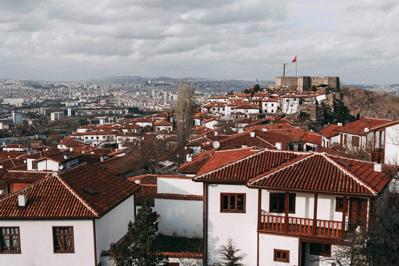
Ankara Castle (Ankara Kalesi) — the medieval citadel on the steep limestone outcrop at the centre of the old Ulus quarter. The lower walls are Byzantine; the upper walls are Seljuk and Ottoman; within the citadel a warren of restored Ottoman houses now contains restaurants, antique shops, and the small Çengelhan Rahmi Koç Museum. The view from the top across the city to the modern centre and the surrounding plateau is the standard view of Ankara.
The Anadolu Medeniyetleri Müzesi (Museum of Anatolian Civilisations) — housed in the restored Mahmut Paşa Bedesteni (a 15th-century Ottoman covered market) and the adjoining Kurşunlu Han (a 15th-century Ottoman caravanserai) at the foot of the citadel — is widely reckoned the finest archaeological museum in Türkiye. Its collections cover the entire prehistory and ancient history of Anatolia, with extraordinary holdings from Çatalhöyük (the Neolithic plaster reliefs and the great seated mother goddess), the Hittites (the colossal lion gates from Alacahöyük, the relief sculptures from Hattuša), the Phrygians (the great gold and bronze finds from the Midas Tumulus at Gordion), the Urartians (the bronze ceremonial objects from the eastern citadels), and the Greco-Roman, Byzantine, and Islamic periods.
Other essentials of any visit: the Temple of Augustus and Rome with its Monumentum Ancyranum inscription, in the Hacı Bayram complex; the Hacı Bayram Camii itself; the Roma Hamamı (Roman Bath) excavated north of the Hacı Bayram complex; the Augustus's Column (Belkıs Minaresi, the "column of Julian the Apostate" from 362 CE) near the old city; and the Ethnography Museum (Etnografya Müzesi) in Ulus, in which Atatürk was first buried before the construction of Anıtkabir.
xii.Visiting Ankara Today
Ankara is reached by air from across Türkiye and most major international cities into Esenboğa International Airport (ESB), twenty-eight kilometres north of the city; by high-speed train from Istanbul (about four and a half hours) and Konya (under two hours); or by long-distance bus from anywhere in the country. The modern city is best navigated by metro, which connects the old core at Ulus down through Sıhhiye, Kızılay, the embassy district, and on to METU and the southern suburbs.
Two days is a reasonable minimum: a full day for Ulus (Ankara Castle, the Anadolu Medeniyetleri Müzesi, the Hacı Bayram complex with the Temple of Augustus, the Roma Hamamı, the Ethnography Museum, lunch in the citadel); a full day for the modern city (Anıtkabir, the Atatürk Orman Çiftliği, the diplomatic quarter at Çankaya, dinner in Kızılay). For travellers with more time, the Gordion archaeological site — the Phrygian capital with the Midas Tumulus — is a comfortable day-trip ninety kilometres south-west of the city, and the wider central Anatolian country to the south leads toward Cappadocia.
The Ankara table is a plateau table: Ankara tava (slow-cooked lamb with rice), simit (the sesame-crusted ring bread, sold from carts on every corner), the famous Ankara şehriyesi (a regional noodle soup), and the pastries of the old Ulus bakeries. The Atatürk Orman Çiftliği brewery still produces Tekel Birası in its original recipe. For the broader Anatolian table, see Anatolian Tables; for the recipes, our sister site TurkishCooking.com.
For the Anatolian Seljuk capital that Ankara passed under after 1071, see Konya. For the surrounding archaeology — Hittite Hattuša, the Phrygian Gordion — see the Civilisations page. For state-level Türkiye geography and political institutions, our sister site CountryOfTurkey.com.
Sources
- Internal sources:
- T.C. Ankara Valiliği Kültür ve Turizm İl Müdürlüğü, Ankara Rehberi (2014) — the primary chronological spine.
- Internal review file:
content-review/sources/cities/ankara.md— translation and research notes. - Cross-references: Konya (Seljuk capital after 1071); Civilisations (Hittites, Phrygians, Galatians).
- Scholarly references:
- Mitchell, Stephen. Anatolia: Land, Men, and Gods in Asia Minor, 2 vols. Oxford: Clarendon Press, 1993. — Volume I includes a major treatment of Roman Galatia and Ancyra, including the Monumentum Ancyranum and the Galatian-Roman administrative history.
- Cooley, Alison E. Res Gestae Divi Augusti: Text, Translation, and Commentary. Cambridge University Press, 2009. — The standard modern edition and commentary on Augustus's Res Gestae, including the Monumentum Ancyranum's centrality.
- Mitchell, Stephen, and Marc Waelkens. Pisidian Antioch: The Site and Its Monuments. Duckworth, 1998. — For the wider Roman Galatian provincial context.
- Cahen, Claude. The Formation of Turkey: The Seljukid Sultanate of Rûm, Eleventh to Fourteenth Century, ed. and trans. P. M. Holt. Longman, 2001. — For the post-Manzikert Seljuk and Ilkhanid administration of Ankara.
- Imber, Colin. The Ottoman Empire, 1300–1650. Palgrave Macmillan, 2002. — For the Battle of Ankara (1402) and the Ottoman Interregnum.
- Mango, Andrew. Atatürk: The Biography of the Founder of Modern Turkey. John Murray, 1999. — The standard English biography; the Ankara chapters cover the 1919–1923 establishment of the capital.
- Zürcher, Erik J. Turkey: A Modern History, 3rd ed. I.B. Tauris, 2004. — Standard reference for the Republican-period transformation of Ankara.
- Web and institutional sources:
- T.C. Ankara Valiliği — Provincial Governorate, official site
- T.C. Kültür ve Turizm Bakanlığı — Ankara İl Kültür ve Turizm Müdürlüğü (Anadolu Medeniyetleri Müzesi, Anıtkabir, Etnografya Müzesi, Roma Hamamı, Temple of Augustus)
- Anıtkabir Komutanlığı — official site of the Atatürk Mausoleum
- TBMM (Türkiye Büyük Millet Meclisi) — Grand National Assembly official site, founding history
- TÜİK (Türkiye İstatistik Kurumu) — Ankara province population and demographic data, 2022 census
- Anadolu Ajansı — Turkish state news agency — current reporting on capital-city affairs.
- Diyanet İşleri Başkanlığı — İslâm Ansiklopedisi, entries on Ankara, Hacı Bayram Veli, Eretnaoğulları.
- Encyclopædia Britannica — entry on Ankara (cited for population, monuments, and modern descriptive material).