i.The Gulf and the Mother Goddess
İzmir is built around a long blue gulf — one of the deepest natural harbours of the eastern Mediterranean — that drives some forty kilometres inland from the Aegean and narrows to a hooked bay at its eastern end. The city sits in the elbow of that hook. On three sides it is closed by mountains: Yamanlar Dağı rises across the bay to the north, Nif Dağı closes the plain to the east, and the long ridges of the Bozdağlar lie further inland toward Manisa. Westward the gulf opens to the sea, between the Karaburun peninsula on its northern shore and the Çeşme peninsula on its southern, before letting out into the open Aegean opposite the island of Chios. To stand on the Kordon — the wide quayside promenade where the city meets the water — at a winter sunset, when the sky behind Karaburun goes amber and the mountains across the bay turn navy, is to understand at a glance why ships have come here, and cities risen here, for nine thousand years.
The name itself is old, and its origin lies somewhere in the deep Anatolian layer that predates the Greek language. The form İzmir is the Turkish reshaping of Smyrna, and Smyrna in turn appears in late Bronze Age Hittite-period names for the region. One tradition, preserved in the modern Valilik's account, derives the word from an old root associated with the Mother Goddess — the Anatolian mother divinity whose cult ran continuously here from the Neolithic into Greek and Roman times, becoming Kybele to the Phrygians and, on this coast, fusing into the Artemis of Ephesus. The city's name, on that reading, is the name of a sacred spring or pool at her sanctuary. Whether or not the etymology is correct, the cultural fact behind it is real: this whole stretch of coast was, for the deepest layer of its history, her country.
ii.Bayraklı and the Bronze Age Foundations
The oldest İzmir is not where the modern city is. Cross the bay to the northern shore and you reach Bayraklı, today a working-class district of high-rises and seafront cafés, where a low rise of ground called Tepekule marks the höyük of Old Smyrna. Excavations begun in the 1940s by Ekrem Akurgal and continued by Turkish and British teams have established that this mound was inhabited continuously from around 3000 BCE — the same horizon as the lower city of Troy across the Aegean to the north — and that by the early Iron Age it carried a small but architecturally remarkable Greek-period town, with mud-brick houses, paved streets, and a temple to Athena.
What the Bayraklı mound tells the visitor, even now, is that the gulf has been a city-place since long before Greek or Anatolian-language settlement can be cleanly disentangled. The Bronze Age layers at Tepekule are part of the same broad pattern that runs from Troy southward along this coast: small fortified settlements on rises near safe harbours, in continuous contact with the Aegean islands and the Greek mainland. By the time the surviving textual record begins, in the 8th and 7th centuries BCE, Smyrna was already old.
iii.The Aeolian Foundation, the Ionian Seizure, and Lydian Alyattes
For the historic-period city the earliest narrative comes from Herodotus. He records that Smyrna was founded by the Aeolians — the northern of the three Greek dialect-groups that settled western Anatolia in the early Iron Age — but that the city was soon seized by Ionians, the dialect-group whose dozen great cities (Miletus, Ephesus, Phocaea, Erythrai, Clazomenae among them) lined the same coast to its south. The seizure was peaceable, in the version Herodotus gives: a group of Ionian Colophonians, exiled from their own city, were received as guests at the Smyrnaean festival of Dionysus and locked the gates behind their hosts. The city after that was Ionian.
By the 7th century BCE Smyrna was, in Britannica's summary, "a stately city," with "massive fortifications and blocks of two-storied houses" — the houses, indeed, are among the earliest known examples of regular urban planning in the Greek world. The lyric poet Mimnermus wrote here in the 7th century, and a long-standing tradition — disputed by ancient authors and modern ones alike — claimed Smyrna as one of the seven cities that contended for the birth of Homer. Around 600 BCE the city was captured and destroyed by Alyattes, king of the Lydian dynasty whose capital lay at Sardis inland, and Smyrna ceased to exist as a city, in any meaningful sense, for some three hundred years.
iv.The Refounding at Mount Pagus
The Smyrna we know was refounded in the late 4th century BCE — Strabo gives the credit to Alexander the Great, who is said to have decided on the new site after a dream, but the work is more likely to have been completed by his successors Antigonus and Lysimachus. The new city was not on the old Bayraklı höyük but four kilometres south, at the foot of Mount Pagos — the steep conical hill that the Turks would later call Kadifekale, "the velvet fortress." From this hill the new Smyrna looked westward down the gulf, with its harbour at its foot and its agora on the slope. The street grid laid out in the Hellenistic period is broadly the grid the central city still follows today.
v.Roman Smyrna — "First City of Asia"
Under Roman rule, after Asia became a province in 133 BCE, Smyrna rose to be one of the three or four great cities of the eastern Mediterranean. It competed openly — sometimes bitterly — with Ephesus to the south and with Pergamum to the north for the title "first city of Asia." Roman emperors visited; the Smyrnaean rhetorician Aelius Aristides wrote, in his Smyrnaikos (oration 17), a hymn to the city's beauty and order; an earthquake under Marcus Aurelius drew imperial gold for the rebuilding. The city had a school of medicine, a school of rhetoric, a library, and the Roman agora — its colonnaded marketplace — whose lower courses survive today as an open-air archaeological site at the foot of Mount Pagos, in the modern Namazgâh district, a short walk above Kemeraltı.
It is also under Roman rule that Smyrna enters the Christian record. The city was one of the Seven Churches of Asia addressed in the Book of Revelation, and in 156 CE — by the traditional dating — the elderly bishop Polycarp, a pupil of John the Apostle, was martyred in the stadium below the citadel. The site is still pointed out. The Smyrna church appears again in early-Christian and Byzantine sources as one of the steady, well-established sees of the Asian coast.
vi.Byzantine, Aydın Beylik, and the Coming of the Ottomans
Through the long Byzantine centuries Smyrna remained a working coastal city — smaller than its Roman self, but never deserted. After the battle of Manzikert in 1071 the Turkish raiding bands reached the Aegean coast, and in the early 14th century the Anatolian Turkmen principality of the Aydınoğulları — based at Birgi and then at the inland town of Ayasuluk — took the upper city. The Aydınoğlu Umur Bey made İzmir a base for one of the most celebrated of the medieval Turkish naval enterprises, raiding from here as far as the Black Sea and the Greek mainland.
The lower city, on the harbour, fell into the hands of the Knights Hospitaller of Saint John in 1344 — they held it as a Latin Christian outpost for nearly sixty years, until Timur sacked it in 1402 on his return march through Anatolia. After Timur the city was reunified under the Ottomans during the reigns of Mehmed I and Murad II; Britannica places the definitive annexation around 1425. Two devastating earthquakes — in 1688 and 1778 — broke the Ottoman city more than once, and each time it rebuilt itself on the same hooked shore.
vii.The Late Ottoman Port and the Cosmopolitan City
From the late 16th century onward İzmir grew into something that, in its time, was almost unique among Ottoman cities: a great Mediterranean port whose commercial life ran through five or six languages and at least as many religious communities. The 1573 attachment of the city to the Kaptanpaşa eyaleti — the maritime province of the imperial admiral — gave it a strategic naval role. By the 17th century English, Dutch, French, and Venetian merchants kept consulates and warehouses along the quay; Greek, Armenian, and Sephardic Jewish communities ran much of the long-distance trade; and the older Turkish quarters rose on the slopes of Mount Pagos behind the harbour. The historian Daniel Goffman, in Izmir and the Levantine World, 1550–1650, traced how the city's commercial rise drew labour, capital, and confessions from across the eastern Mediterranean basin into a single, polyglot urban economy. In Ottoman colloquial speech the city was sometimes called İzmir gâvurlu — "İzmir of the unbelievers" — a tag that captured, half-affectionately and half-warily, just how many Christian and Jewish quarters made up its waterfront.
In 1843, under Said Mehmed Paşa, İzmir became — intermittently from then onward — the seat of the Aydın eyaleti, the larger Aegean province of which it was already the main port. The 19th century saw the city's modern face take shape: the Kordon waterfront filled out with new stone buildings and consular residences; the railways to Aydın (1856) and to Kasaba (1865) — both the work of British engineers — pulled the produce of the great Aegean valleys, the tobacco, the figs, the cotton, the raisins, into the harbour; and the city's exports made it one of the largest commercial entrepôts of the Ottoman world.
viii.İşgal and Kurtuluş — 15 May 1919 to 9 September 1922
On 15 May 1919, six months after the Armistice of Mudros that ended Ottoman participation in the First World War, Greek forces — disembarking under the supervision of the Allied fleet — landed at İzmir. The day is observed in the Turkish national calendar as the start of the period of occupation (işgal). It was also, in the Turkish historical reading, the spark of the National Struggle: news of the landing reached Mustafa Kemal Paşa shortly before he sailed for Samsun on 19 May to begin the organisation of the Anatolian resistance.
The occupation lasted three years, four months, and three weeks. During that time the front line between the advancing Greek army and the forming Turkish national army moved deep into western Anatolia, reaching, at its furthest extent in the summer of 1921, the Sakarya river only some seventy kilometres west of Ankara. From there it began to be pushed back. On 26 August 1922 the Turkish army opened the Büyük Taarruz — the Great Offensive — along the Afyon front; within two weeks the Greek front in Anatolia had collapsed. On the morning of 9 September 1922, advance Turkish cavalry units reached the outskirts of İzmir. By midday the Turkish flag had been raised, in turn, at Kadifekale, at the Sarıkışla barracks, at Karşıyaka across the bay, at the Paket Postanesi on the quay, and at the Hükûmet Konağı in Konak Square. The date is observed every year as the city's Kurtuluş — its Liberation — and is the principal civic holiday of İzmir.
Fire swept through much of the old city in the days that followed, destroying large parts of the waterfront quarters. The Armistice of Mudanya on 11 October 1922 ended the fighting; the Treaty of Lausanne, signed on 24 July 1923, ended the war and recognised the boundaries of the Republic that would be proclaimed three months later. Under the convention on the exchange of populations signed at Lausanne in January 1923, the remaining Greek-Orthodox population of the Aegean coast was exchanged with the Muslim population of mainland Greece, and the cosmopolitan demography of the late-Ottoman city closed.
ix.The Republic and the Modern Metropolis
Republican İzmir rebuilt rapidly. The burned waterfront was redrawn as a planned modern district; the wide Kültür Park — laid out in 1936 over part of the old ground — became the home of the annual İzmir International Fair, which from the 1930s onward was the principal commercial fair of the young Republic. Ege University was founded in 1955 in Bornova, Dokuz Eylül University (named for the date of liberation) in 1982; together they made the city one of Türkiye's main higher-education centres.
The modern province is the country's third-largest by population, with about 4.49 million inhabitants in the 2024 address-based registration count published by TÜİK, after İstanbul and Ankara and ahead of Bursa. The metropolitan municipality covers thirty districts. The most populous are Buca (~521,000), Karabağlar (~468,000), and Bornova (~452,000); each is a city in its own right by European standards. The port is one of the busiest container ports in the eastern Mediterranean; the city's industries run from textiles, cement, and food processing through petrochemicals at Aliağa to the older Aegean staples of olive oil, tobacco, figs, cotton, and the dried fruit of the Manisa and Aydın valleys. Politically and culturally the city has, since the Republic, kept a markedly secular, civic, and Aegean character that distinguishes it from the inland Anatolian cities — what people in Türkiye mean when they speak of the İzmir kafası, the "İzmir mind."
x.What to See, in Order
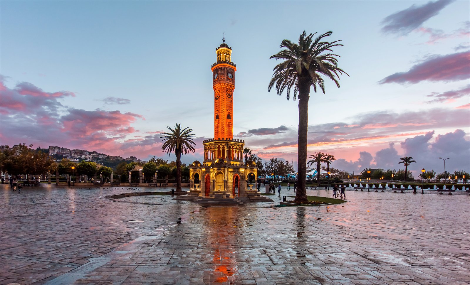
The walking shape of historic İzmir is small. From the Kordon waterfront, the route runs inland and uphill: across Konak Meydanı with its 1901 clock tower (Saat Kulesi), gift of Sultan Abdülhamid II, and the elegant little Yalı Camii beside it; into the labyrinthine Kemeraltı bazaar with its kervansaray courts and the 16th-century Hisar Camii; out the eastern side of Kemeraltı to the Roman agora, an unexpectedly intact open-air monument set among Ottoman house-fronts; and on up to the citadel of Kadifekale, the medieval rebuilding of the Hellenistic-Roman Mount Pagus walls, from which the gulf, the city, and on a clear morning the Aegean itself open below the visitor in a single panoramic view. The Archaeology Museum at Bahribaba and the Atatürk Müzesi on the Kordon are the principal indoor stops. For the deepest layer — Bronze Age and Iron Age Smyrna — one crosses the bay by ferry to Bayraklı, where the Tepekule excavations are now arranged as an open-air park.
Around the city, the province carries some of the densest concentration of ancient sites in Türkiye: Ephesus and the basilica of Saint John at Selçuk, an hour south; Pergamum at Bergama, two hours north; the Ionian sites of Erythrai, Klazomenai, Teos, and the Aydınoğlu coast at Foça. Each will have its own essay in this magazine in time.
A city of the gulf — opened to the sea by its harbour, closed inland by its mountains, rebuilt on its own ground after every rupture, and named, in the end, for the Mother.
For the wider Ionian story of which Smyrna was a part, see — in time — the planned essays on the civilisations of Asia Minor and on the great Greek cities of the western coast. For another Aegean-facing city of the Republic, see the Aegean regional overview. For Türkiye's full state geography — coastlines, borders, the Mavi Vatan doctrine — visit our sister site CountryOfTurkey.com.
Sources
- Internal sources:
- T.C. İzmir Valiliği — historical sketch, "Geçmişten Günümüze" and "Medeniyetler Beşiği" (izmir.gov.tr/medeniyetler-besigi), the primary spine for this essay's chronology, the name etymology, and the framing of the 1919–1922 period.
- T.C. Kültür ve Turizm Bakanlığı — İzmir İl Kültür ve Turizm Müdürlüğü, "Tarihçesi" (izmir.ktb.gov.tr/tr-91057/tarihcesi.html) and the Smyrna (Bayraklı Höyüğü) Kazısı page for the Tepekule excavations.
- Cross-reference: Ephesus and Pergamum for the Roman-period contest for "first city of Asia," and the regional context of the Aydın and Saruhan beyliks.
- Scholarly references:
- Cook, J. M. The Greeks in Ionia and the East. London: Thames & Hudson, 1962. — The standard short account of the Aeolian and Ionian foundations on the western Anatolian coast, including Old Smyrna at Bayraklı.
- Mitchell, Stephen. Anatolia: Land, Men, and Gods in Asia Minor, 2 vols. Oxford: Clarendon Press, 1993. — Smyrna and the cities of Roman Asia, the imperial cult, and the late-antique transformation of the western coast.
- Goffman, Daniel. Izmir and the Levantine World, 1550–1650. Seattle: University of Washington Press, 1990. — The Ottoman commercial rise of İzmir, the consular system, and the cosmopolitan demography of the early-modern port.
- Web and institutional sources:
- T.C. İzmir Valiliği — izmir.gov.tr (official site of the Governorate), including the demographic page for the third-province ranking.
- T.C. Kültür ve Turizm Bakanlığı — İzmir İl Kültür ve Turizm Müdürlüğü, Tarihçesi.
- TÜİK (Türkiye İstatistik Kurumu) — Adrese Dayalı Nüfus Kayıt Sistemi (ADNKS), 2024 results: İzmir provincial population 4,493,242; veri portalı bülteni.
- Anadolu Ajansı — "Kurtuluşun simgesi 9 Eylül" on the 9 September 1922 liberation and the AA's role in announcing it.
- AFAD (T.C. İçişleri Bakanlığı, Afet ve Acil Durum Yönetimi Başkanlığı) — Press bulletin on the 30 October 2020 İzmir / Seferihisar earthquake (M6.6).
- Encyclopædia Britannica — entry on İzmir, used for cross-checking the dating of the Alyattes destruction, the 4th-century-BCE refounding at Mount Pagus, the c. 1425 Ottoman annexation, and the 1688 and 1778 earthquakes.